Bodega Cove

Before we headed for one of three anchorages in lower Tahsis inlet, I launched the drone to get a good look at Nuchatlitz at low tide. When you compare this video with the ones shot the previous day, the contrast is telling. Drying areas that extend right up the channel markers, back coves that are clearly only accessible at higher tides, and anchorage surrounding the main bay that shrink to one boat holes.

The day was grey and overcast. We passed a few fish farms and the old mission at Esperanza, and saw the Coast Guard “Cape Dauphin” as we exited the Tahsis narrows. The Cape Dauphin was traveling at warp speed, towing a search and rescue tender. We think they must have been doing a drill, as they’d slow way down, and then start back up again. Interesting.

And then it started to rain. Rather than pressing on to Santa Gertrudis, Karen picked Bodega Cove as our first anchorage to look at. It was reasonably attractive, not marred by logging and empty of other cruisers, so it became our home for the evening. The most interesting navigation element was the short transit of Princesa Channel.

Much is written about the “rocks” that populate this pass. They are well charted, but the visual picture is a bit confusing and there is some current. I slowed to a low cruise speed at 1000 rpm’s, which gave us plenty of rudder authority. More importantly,  it reduced the size of our turning radius. This added maneuverability and the fact that a slower speed gives you more time to assess the situation and make adjustments really helps with navigation in tight and winding spaces.

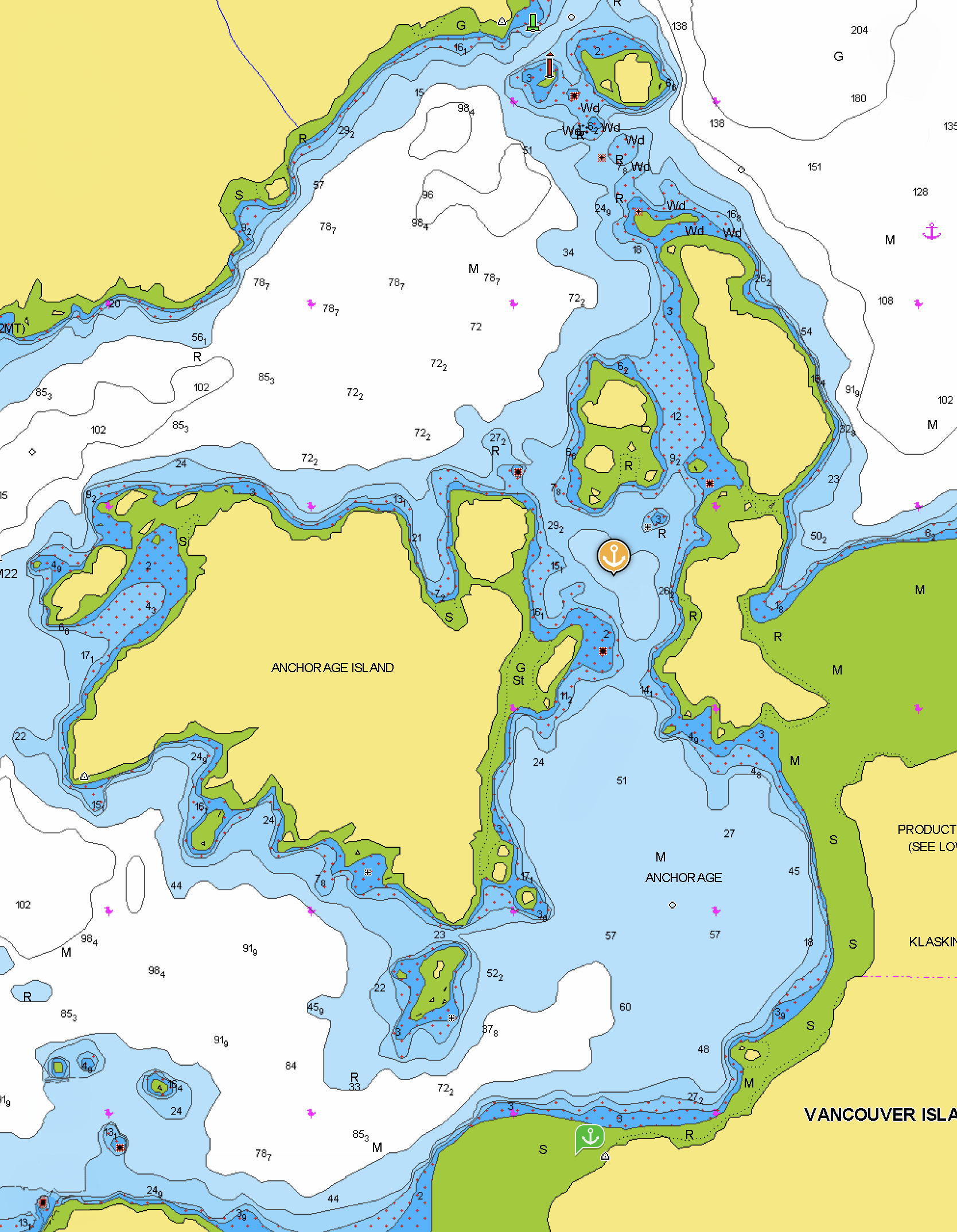
Bodega Cove is accessed through a narrow but straight channel with plenty of water and no surprises, Anchor in 30 feet in the first large opening and you’ll swing with the tide in good holding and great protection from all directions. The weather and tide cycle timing kept us from exploring the inner cove this time.

Bodega Cove

Bodega Cove Not for navigation

West Battle Bay Anchorage

The weather is forecasted to calm down today but pick back up again tomorrow with SE winds instead of our preferred NW winds given our direction of travel. So, it is time to leave Klaskino and head to West Battle Bay Anchorage, one of our favorite stops after rounding the Brooks Peninsula. We've anchored in both West Battle Bay and the Bunsby Islands, and we prefer Battle Bay because it doesn't feel as enclosed and is very close to a wonderful sandy beach. However, it is exposed to the southeast.

We had a good rounding of Brooks Peninsula, starting with winds less than 5 knots from Klaskino nearly all the way to the end of the Penninsula. On this leg, we were hailed by the Cascadia, a 125’ passenger charter catamaran that is part of the Maple Leaf Group. We had seen her several times on our AIS in Quatsino Sound. She had just rounded Brooks from the other direction. The captain contacted us on the VHF for the sole purpose of chatting. We traded stories about our vessels, and he gave us a forecast for Solander Island that turned out to be accurate - it included both humpback whales and puffins.

As we moved to the second leg of the three sides of the Peninsula, the wind and waves started to build. By the time we made the third and final turn the winds reached 20 knots but the seas were on our stern, providing a nice enough ride in the following seas.

There was also some fog, but it was variable, ranging from ¼ mile to 1 ½ miles, and lasted only an hour. However, it totally obscured Solander Island as we came abeam it.

West Battle Bay looks cozy on the charts, but after you set anchor and look back out to the East that feeling goes away. It does mean that you’re open to the effects of easterly winds and fetch, so the anchorage is not ideal in all conditions. If wind is predicted from an easterly quadrant, then it’s a short trip to reposition to the Bunsby Islands where you can find protection in all weather conditions.

West Battle Bay NOT FOR NAVIGATION

West battle Bay Anchorage

When we last visited here in 2012, I made nachos for dinner. Somehow I got everything right because we raved about them so much we christened them “Battle Bay Nachos.” I put a recipe in my files but somehow they are never as good as we remember. Nevertheless, our location called for another attempt. Well, I can only conclude that this anchorage is the key, becasue they lived up to our memories.

Battle Bay Nachos, best enjoyed in Battle Bay

The next day, we visited what we call Kayak Beach — located in Battle Bay— because there is always an encampment of kayakers tucked in the north corner. There is a long sand and pebble beach that is fun to walk and inspect the occasional interesting rock or shell. Even though there is a kayaker camp, no one was there today and we were all alone on the beach.

We also made a slight sojourn over to the river that flows into the bay. We always discuss giving the river a try in the dinghy at high tide, but it never looks inviting. I did take the drone up the river to get a better look, but I’m still not convinced it is something I want to try. I know other cruisers have done it, but I need to have a better feeling than the one I get when I look at that river. Maybe some footage from the drone will help convince me.

West BaTTLE bay Kayak camp

beautiful beach in battle bay

With the forecast predicting SE winds building, we made our way to Scow Bay in the Bunsby Islands. It’s a fine anchorage and the most protected in the area. All the boats that we previously spotted on AIS were gone, so we had our choice of spots to drop the hook. As we did in 2012, we tried tucking back in the SE corner, but ultimately went back to where we finally anchored in 2012, closer to the middle in 50 feet. We should have referred to our 2012 blog entry first to save some time.

As the evening approached, we spotted M/V Marlinda, a 130-foot Delta, on AIS. Her destination was listed as the Bunsby Islands. She stayed just ahead of the fog and found her spot in South Bunsby Cove. Just before she entered Gay Passage, her tender, Little Marlinda, decoupled and took the lead. Little Marlinda scouted the route ensuring no surprises for big Marlinda. We often do that with our dinghy in tricky entrances, but she’s not 33 feet in length.

Klaskino Inlet

Both Klaskish Basin and Klaskino Inlet are popular staging areas before going around Brooks Peninsula. As we have visited and enjoyed Klaskish twice, we decided to check out Klaskino. We were not disappointed. We tucked in behind Anchorage Island. On the charts, it looked very small, but it was actually cozy and not cramped. It's one of those places where you don't feel hemmed in because of the 360-degree views. You remain well-protected from the weather that can plague the north side of Brooks.

Klaskino InleT looking out to the pacific ocean

Our trip here was unremarkable as we made our way down Quatsino Inlet to the Pacific. About 2 miles before we exited the Inlet, we did start to notice a hint of ocean swell. Like most of the West Coast of Vancouver Island, the transition from deep ocean to the shallower inlets results in a rugged bottom and outcroppings of reefs and islets. The charting is excellent, so finding your way through and/or around the obstructions is easy. But the side effect is that the seas can be "disturbed" even on a calm day. Whenever possible, we try to move offshore tracing the 20 to 30 fathom line to reduce the effect. Not only is the confused sea from the ragged uplift sea bottom reduced, but the echo waves that "bounce" off the land and return to the seas are greatly mitigated.

impossible to capture the grandeur from going from the ocean, past the guardian islwts into the Quatsino Inlet with mountian in the distance. the view extends left and right as far as the eye can see.

Our plan is to stay for two days, waiting for a calm weather pattern to round Brooks. During this time, we will relax, take care of boat chores, and explore. We did take the dinghy and went through Scoular Pass to investigate anchorages on the "inside." The inside seemed like it would offer even more protection from harsh weather. However, the water is deeper and shoals quickly, so finding a good place to drop anchor takes some time. I suggest referring to Dreamspeaker for suggestions on anchoring in this location. We did not find it as attractive as our anchorage in the “basin.”

We also took the dinghy a ways up the inlet, just to see what we could see. Mostly sea otters with pups, but they were quite shy and were not interested in us.

sea otters checing us out in our dinghy

Back at the boat, in our totally isolated anchorage, Karen thought she heard a “go fast boat” approaching. Sure enough, an 18’ skiff came around the corner. A dad, his daughter and their dog stopped by to say hello – they were anchored in Klashkish but wanted to take a look at Klaskino.

our spot behind anchourage island

good view to see the rocks that guard both entrances

another view of the anchorage

behind a peak at the drying flats east of our anchorage in klaskino

Mother NAture Puts on a show for us.

The next day, a large dinghy came through the anchorage but did not stop to chat. They looked like they turned up the inlet and then departed out Scouler Pass later that afternoon. Scouting for a good anchorage, perhaps? Maybe the folks we met on the skiff the day before had encouraged another boater to take a look?

On our last morning in Klaskino, we saw an AIS target approaching from Klaskish, a very large yacht called Rushmore. She came in and anchored in the published spot, leaving us plenty of room in our basin. Sure looked like she carried that dinghy we saw checking things out yesterday!

M/V Rushmore

Coal Harbour, Marple River, Julian Cove

Before our one-hour cruise over to Julian Cove today, we spent part of the morning visiting Coal Harbour by dinghy (about 3 ½ miles) We wanted to visit the “museum” housed in the old RCAF Seaplane Hangar. It is a bit of a hoard of relics, but nevertheless has some fascinating items from the area’s past, including WWII memorabilia, a wall of chain saws, a bear with a flintlock, and a Ford Model A and T. Worth a trip if you’re in the area. Entry is through the AirCab office.

Old RCAF Seaplane hanger. Now aircab.

inside the massive hanger.

jawbone from a 92 foot blue whale that was shot in 1962.

one of the many rooms dedciated to the history of the area.

RCAF and other aviation artifacts.

security officer on guard.

aircab docks

Our early afternoon excursion was a trip back up the Marble River. This time we had another foot under our keel and there were breaks in the clouds which made for even more spectacular scenery than yesterday. It’s a must-do trip and the highlight of Quatsino Sound for us.

The advice on going with at least an eight-foot tide is spot on. Two feet less and we probably would not have made it past some of the shallows. Leaving the boat an hour before high tide at Makwaziniht Island let us reach the end of the navigable water at the big cave and the 90-degree bend in the river. There is a nice rock pile upon which to beach the dinghy and get off on the shore opposite the cave. Also, there is plenty of water in the cave to go all the way in and see the weathered formation up close.

We like to drift in the still water within the cave before riding the river current slowly back out. We saw eagles and seals on our journey.

We truly enjoyed our time in Varney Bay.

Moving to Julian Cove was a strategic repositioning for tomorrow’s cruise to Klaskino Inlet. The currents were favorable in Quatsino Narrows, so off we went.

Julian Cove is a well-protected anchorage in Buchholz Passage with tall mountains at the head. We anchored in 40 feet after first determining where the south seabed quickly rises. Make certain you scout out the shoals before picking where you drop your hook.

View looking out from Julian Cove. THe islet with the solo tree is a memorable feature of Julian Cove.

We were the only boat in Julian Cove and had a quiet night.

North Harbour via Cape Scott

Today is the day. The rounding of the dreaded Cape Scott. Well not so much. Neptune has been kind to us the previous two times we rounded the Cape and today he outdid himself. Winds were never more than 5 knots, usually less than 3 and the seas rippled.

As we did the previous two roundings, we chose the Tatnall Reefs route which lets you avoid the Nahwitti Bar and time your arrival at Cape Scott for slack. We were off bright and early, none of the other boats in Bull Harbour were moving when we left and we never spotted them on AIS.

Flat seas are always nice. In addition to the ride, the visibility for spotting critters is vastly improved. Sea otters are easy to see as they lay on their backs and give you the “look” as you pass them by. The whales were all fishing shallow waters which meant no flukes as they gently dove. If it were not for the flat conditions, I don’t know if we would have seen them at all.

As the conditions were “perfect” there is not much to report. We saw only small fishing boats and no other recreational vessels.

an ideal rounding of Cape Scott

Boat chores filled the day are we traded off the helm in two-hour shifts. Though the ride was stellar, we were happy to see Quatsino Lighthouse as we rounded into the Sound. There was a large Canadian Coast Guard Ship, the Sir Wilfred Grenfell anchored off the lighthouse – she’s a patrol vessel built in 1987 and is 225 feet long. Also a welcome sight!

Sir Wilfred Grenfell

North Harbour is not much more than a place behind a small island, but it provides protection from the Pacific and is only three miles inland after you round Cape Perkins. We’ve never been alone here in the past but this year we have it all to ourselves.

north harbour anchorage

Winter Harbour is only a two-mile dinghy ride from North Harbour. There you find the Outpost store, open only in the afternoons, which has a reasonable selection of provisions (mostly packaged/canned) and an outstanding offering of anything having to do with fishing. Why? Winter Harbour is a destination fishing spot given its easy access to prime locations for salmon and halibut.

Given we had such a peaceful rounding of Cape Scott, we were more than ready for take the dinghy over to the Outpost. As I brought the dinghy up on plane enroute to Winter Harbour, my right foot reported it was getting wet.

 “RED ALERT, FULL STOP!”

No, I did not leave the drain plug out of the dinghy. (Karen’s first question) What’s happening? Nothing at slow speed. But once up to speed again, we see water intruding where the dinghy pontoon and the aluminum hull meet. We do a 180 and return to OceanFlyer slowly as we monitor the issue.

After getting the dinghy up and floating on the Steelhead davit at my eye level, I could see that we had a one-foot area where the bond between the pontoon Hypalon and the hull was broken. In the center 3 inches, I could poke my finger through and see that there was a clear path for water to intrude.

We’re going to need some better glue

After looking up repair options online thanks to Starlink and reaching out to my Bellingham buddies s well as aone other friend who had just replaced his pontoons last winter, I developed a plan for repair. We were determined not to be without the dinghy for the rest of the trip.

The Hypalon contact cement in my dinghy repair kit was approaching 5 years old and was rather gelatinous. Also, trying to use contact cement where you first need to keep the two surfaces apart as you apply the cement and as it dries to a tacky surface just wasn’t practical.

One of the internet postings talking about successfully using West System G-Poxy. I am very familiar with that product and have had great success in other applications. As a bonus, I just replaced my supply with new product this Spring, so I knew the epoxy was fresh.

I used the coarse sandpaper that came with the dinghy repair kit to prep the aluminum and the Hypalon, then cleaned the surface with acetone to remove sanding particles and grease.

After applying a generous amount of G-Poxy and squeezing it into every part of the delamination, I covered it with the Gorilla tape to hold everything in place while the epoxy set. The instruction recommends waiting 24 hours before “hard use” if curing at 77 degrees Fahrenheit. As the ambient temperature is not getting out of the low 60’s, I applied heat with my heat gun every hour or so. I also planned to wait 48 hours instead of 24 just to make certain the epoxy has time to fully cure.

Fingers crossed, we settled in to stream TV via our newest friend, Starlink, and had a peaceful evening.

Easy dinner after a long day

North Harbour Senset