Alston Cove to Quigley Creek Cove

This morning’s mission is to dinghy up to the head of the cove and explore the circular fish traps/weirs. We saw these in 2022 and wanted to see them again.

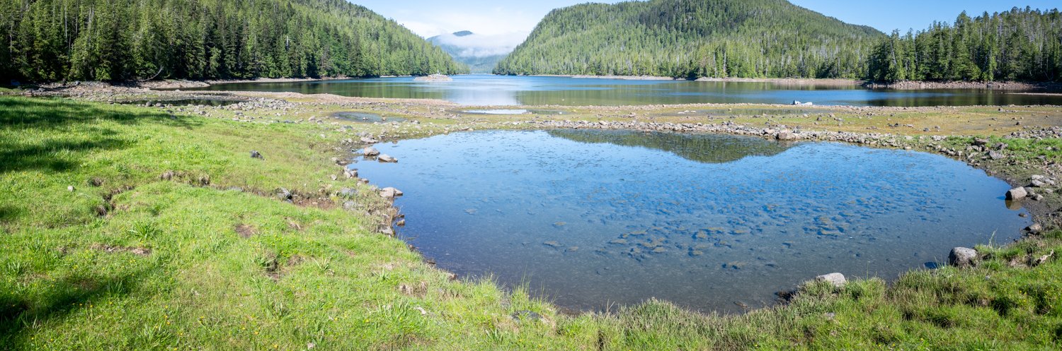
First thing this morning, I took the drone up one more time to look at the approaches to the head of the cove at a low tide of 1.24-feet at Milne Island. These photos, combined with those from yesterday, gave us a very good preview of what our approach should be. It looks like there is lots of water, but it really gets shallow once you are past the large rock.

beautiful morning at alston cove

the approach to the fish traps

this shows the structure of the shallow water at thehead of alston cove

At a 5-foot tide at Milne Island, we saw no fewer than 3 feet of water on our dinghy trip to the shore. I tried to stay in what I thought was the deepest water carved out by the creek on the south side, but no matter, we had enough water.

The best thing about the timing is we had a nice approach and landing on a medium steep rocky shoreline. It was easy to get off the dinghy and secure it to some larger rocks upshore.

Easy landing for the dinghy

it is a short walk up the rock encircled fish traps

We walked along the creek. It’s pretty, but I don’t think you’d get very far upstream even at high tide due to all the rocks. Using Kayaks and portaging over the shallow rapids might work, but we’ll leave that to the more adventurous.

karen scoping out the river to see is we might make it up in the dinghy

We then then walked over to get a look at the circular fish traps. It’s easy walking with a mix of stone, reasonably solid marsh, and firm mud.

view from the fish traps back down alston cove

overhead view of the fish traps

About four of the seven circular fish traps are still intact and held some water at the lower tides. They’re really cool to see.

one of the large fish traps that is still intact

Back to the boat and then off to Quigley Creek Anchorage, which is right at the mouth of Laredo Inlet, about 45 minutes run. It’s a popular anchorage, as it’s not far beyond Meyers Narrows and is just off Thistle Passage.  We were here in 2022, but shared the anchorage with 3 other boats, which was a bit tight given that it’s also a deep anchorage.  The weather wasn’t great when we were here before, and we didn’t explore the creek.

quigley creek cove viewed from the creek entrance

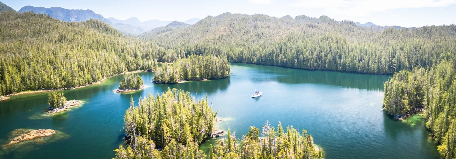
oceanflyer anchored in quigley creek cove

Today is sunny and the tides are right to explore the creek as far as we can at high tide. We entered the anchorage to find it empty, so we could choose our spot. At 1:25pm, we were off to explore. We found 15’ at the entry to the creek on a 12.6 foot tide at Milne Island. It’s really pretty, and we made our way as far as we could, abput one mile. It got quite rocky and we read about 1.8’ on the depth sounder, so we turned around, found a slightly deeper spot and dropped the anchor to just enjoy the peace and quiet and take more pictures.

looking up quigley creek from its entrance

Quigley Creek

After a while, we headed back down the creek, ready to explore all the islets around the anchorage. Unfortunately, we also noticed that the tell tale was no longer streaming water on the dinghy engine. I was really worried, as it would have been a very long row back to OceanFlyer, but I was able to continue under power without overheating the engine – I kept a close eye on the temperature gauge. Nevertheless, we made a beeline straight for the boat to troubleshoot.

Given that the engine didn’t overheat, it pointed to a blockage in the water line to the tell tale hole. I cleaned it out – not finding much – and then dropped the dinghy back into the water to test it. While there was “some” water flowing, it wasn’t normal. Up went the dinghy again, and I tried more aggressive cleaning. I found some black tarry stuff that seemed to be the culprit. And voila – the engine was “peeing” like normal.

 We went out to explore among the island and islets. It was sunny and calm and we had a great time.

The weather is supposed to change, so we soaked up all the sun we could. When we turned in for the night, we were the only boat in the anchorage.

mother nature puts on an impressive show

Chapple Inlet to Alston Cove

Today we head for Laredo Inlet and return to Alston Cove, last visited in 2019.

The weather was bright and sunny, with totally calm seas. The best kind of travel day.

there is calm and then there is this kind of calm

Departing Chapple Inlet, we saw a deer posing at Doig Point. Karen swears we saw the same deer in the same place in 2022. Interesting. This deer waited until we were in good visual range, pranced out of the woods, and then stood there in her glory for adoring fans.

Exchanging glances with the locals

As we turned left into Camaano Sound and the start of Laredo Channel, we could see Haida Gwaii 80 miles away.

We remembered Alston Cove fondly from our prior trip and were interested to see the fish weirs at the head of the bay again. Alston has a cozy feeling due to the narrowish entrance,  despite being spacious once inside, with a pretty valley at its head.

No boats were seen in Laredo inlet as we made our way towards Alston Cove and we had the Cove completely to ourselves for the evening.

McMicking Inlet to Chapple Inlet

 After a great day of exploring the beaches in McMicking Inlet it is time to move on. Karen found an extra day in the schedule, so we’re going to go only 23.3 miles to Chapple Inlet.

The southwest tip of Campania Island has been a reliable spot to see humpback whales, and this year did not disappoint. We saw a pod of five whales. They were making lots of blows in unison.

lots of humpback blows

From a distance I thought it might be bubble feeding, but as we got closer it felt more like they might be herding their prey into more shallow water. There were a couple of small recreational fishing boats in the general vicinity, so that’s probably what was happening. We stopped and watched the whales for a while before continuing on.

We visited Chapple Inlet in 2022, and really liked it so Karen decided we should make a return visit. It’s a long way back to the head, but that’s our preferred spot. As we worked our way into the Inlet, we passed two sailboats who were departing Kiln Bay.

We continued to the very head of the inlet. The shoaling and reefs are well marked on the chart. At low tide the obstructions are mostly visible, but at higher water it’s best to mind the charts and go slow. There are a couple of narrow spots that deserve attention.

 At the head, there is lots of room to swing and the holding is very good in 30-40 feet over mud. It was sunny and we mostly lazed about enjoying the weather and the views.

looking back at oceanflyer from the head of chapple inlet

a good look at the shoaling in chapple inlet

We kept a sharp eye out for critters. No bears, but we saw two sandhill cranes.

Very late in the evening we were joined by a Ranger Tug. The tide was high, and we were worried because it appeared to be on a course towards the charted rocky shoal.

They poked around for a long time and finally dropped anchor. About 45 minutes later, we heard them raise their anchor and reposition themselves 200 feet to the south. My guess is they swung over the shoal, and after doing some math, realized that their location would be a problem when the tide goes out.

McMicking Lay Day

We woke to a beautiful morning, bright sun and a great day for exploring. The rafted fishing boats left early this morning, but we lazed around, waiting for the right tides to explore our favorite beach. The amazing sand beaches are a key reason to visit McMicking, and are almost on par with Pruth or Rugged Point.

Mcmicking anchorage

looking back to the entrance and the beaches from the anchorage

a peekaboo shot from the cove around the corner

The challenge in visiting our favorite beach is two-fold. First, it’s a shallow approach – we prefer a steeper beach drop off to make it easier to maneuver (and depart). Second, the beaches are exposed to swell and some surf, so it’s key to pick your landing spot with care. We have a spot that leverages some rocks to help protect us from the swell and surf.

our favorite place to beach the dinghy using rocks to break up the waves

Although we should probably have waited for the tide to rise a bit, I was able to get Karen to the shore to hold the dinghy painter while we offloaded more lines and the sand spike.

I brought the drone, as it’s hard to capture the grandeur of this beach with a camera at ground level.

this is but one of many beaches along the island

the river empties across the sand to the ocean. you can see this feature on google earth

rocks and sand are the beachs of the coast

The beach was just as nice as we remembered from 2022. Long and wide, with a hoard of sea shell treasures for Karen to beachcomb.

sand and granite mountains are are certain sign you are on campania Island

After capturing the bird’s eye view, I joined Karen as we walked the vast expanse of the beach and found lots of wolf paw prints. We understand there are a lot of wolves in this area, but have yet to be lucky enough to see one.

lots of critter paw prints

After a long while, we decided it was time to return to OceanFlyer. Getting off the shallow shore was a challenge, even with a higher tide and judicious use of the anchor buddy. But we did it successfully and returned to our anchorage slightly windburned but happy.

We had a new neighbor in the anchorage, another small recreational fishing boat. We spent time chatting with the nice Canadian couple before returning to OceanFlyer.